



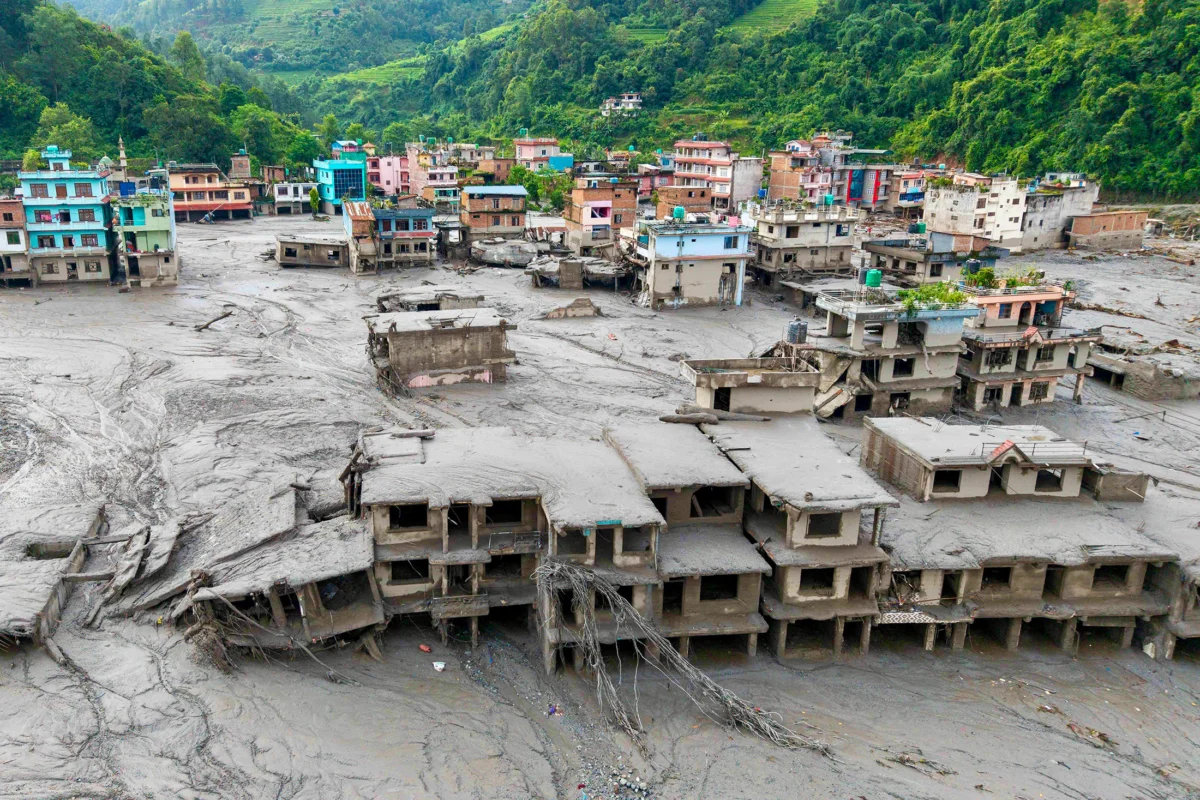
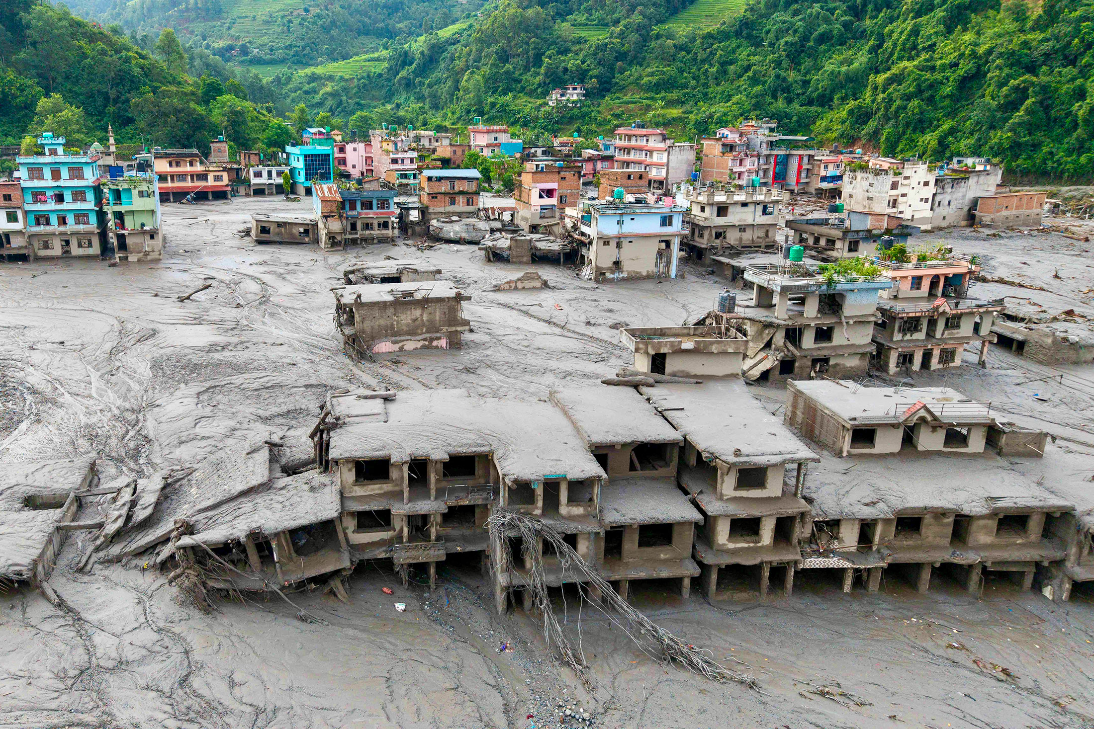
A terrifying wall of mud, ice, and debris has torn through the river valleys of the Nepal-China border, leaving a trail of destruction that has scientists and regional authorities scrambling to comprehend the scale of the tragedy. The disaster, which unfolded in the high-altitude terrain of the Himalayas, serves as a harrowing reminder of the mounting risks posed by a rapidly changing climate in one of the world’s most vulnerable regions.
As international researchers work to piece together the event, the consensus is growing that this was not merely a natural accident, but a manifestation of the "Third Pole’s" accelerating instability.
The Anatomy of a Disaster: Main Facts
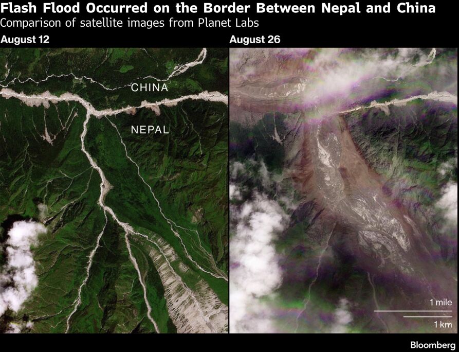
On Wednesday, at approximately 8:37 a.m. local time, the serenity of the high-mountain landscape was shattered. According to the United States Geological Survey (USGS), a 5.2 magnitude seismic event served as the catalyst for a massive glacial collapse.
Simon Allen, a research associate at the University of Zurich specializing in glacial hazards, confirmed that the event was characterized by a massive ice avalanche. “There was a large ice avalanche, likely a volatile mixture of ice and rock, which detached from the mountain face, became fluid, and transformed into a devastating debris flow,” Allen stated.
Unlike traditional river flooding, this event behaved more like an "inland tsunami." As the glacial snout—located at an elevation of roughly 5,200 meters—broke away, it plummeted down the steep valley walls. Dan Shugar, a geomorphologist at the University of Calgary, explained the physics of the horror: “When you have a massive volume of rock falling such a great distance, it generates an immense amount of heat. That kinetic energy melts the ice upon impact, which explains the sheer volume of water and fluid sediment seen in the horrific footage emerging from the region.”
A Chronology of the Event
While the full sequence of events remains subject to ongoing satellite verification due to heavy cloud cover, the timeline of the catastrophe has begun to emerge:
- 8:37 a.m. (Wednesday): A 5.2 magnitude seismic event strikes the China-Nepal border. Initial reports erroneously identified the event as a 4.4 magnitude earthquake, but subsequent analysis of seismic stations and satellite imagery confirmed the shaking was a result of the massive glacial collapse itself.
- Late Morning: The debris flow enters the Lende Khola, a vital tributary of the Bhote Koshi River. The surge of water, sediment, and boulders begins its descent, obliterating infrastructure along its path.
- Afternoon: Reports of widespread destruction emerge. The flood travels an estimated 170 kilometers (106 miles), tearing through settlements and critical transport arteries.
- Ongoing (24-48 Hours Post-Event): An international coalition of scientists begins a collaborative data-sharing effort, utilizing hydrology, seismology, and remote sensing to map the source area, which remains largely inaccessible to human observers.
The "Third Pole" Under Siege: Supporting Data
The region—often referred to as the "Third Pole" because it contains the largest store of freshwater outside the polar regions—is experiencing the effects of climate change at a rate far exceeding the global average.
Scientific studies, including a landmark 2019 report, indicate that the high-altitude region is warming at nearly double the global pace. This thermal stress is causing glacial retreat at an unprecedented speed, with ice masses in the area shrinking twice as fast since the turn of the millennium compared to previous decades.
The instability of the permafrost and the retreat of glaciers create a "ticking time bomb" scenario. As glaciers pull back, they leave behind precarious slopes and unstable glacial lakes. While researchers note that historical records are not yet robust enough to statistically confirm a definitive increase in the frequency of these specific avalanches, the pattern is undeniably consistent with climate models predicting an uptick in "cryosphere hazards."
Expert Analysis and Official Responses
As news of the disaster broke, experts were ironically already gathered in Chengdu, China, for an annual summit dedicated to mitigating the risks of mountain hazards. The timing has galvanized the scientific community, which is now calling for urgent, coordinated action.
"We are seeing that we should expect these events to become more frequent," said Simon Allen. "When you synthesize the data—the retreating glaciers, the thawing permafrost—it all adds up to a clear, systemic threat."
The International Centre for Integrated Mountain Development (ICIMOD) is currently leading a preliminary assessment to verify the extent of the damage in the Lende Khola basin. Mohd. Farooq Azam, a senior cryosphere specialist at ICIMOD, expressed frustration with the pace of current mitigation efforts. "The pace of change is so fast that our ongoing efforts are not able to cope," Azam remarked. "Regional governments must move beyond national boundaries and take consolidated, cross-border steps to manage these hazards."
The lack of early warning systems has been a central theme in the post-mortem discussions. Andrew Gissing, CEO of Natural Hazards Research Australia, emphasized that while some regional efforts exist, they are vastly insufficient. "The event occurred without warning, catching those downstream entirely off-guard," Gissing noted. "Early warning systems are not just technology; they are life-saving infrastructure that must be prioritized immediately."
Implications for the Future
The disaster has implications far beyond the immediate loss of life and property. The highway impacted by the flood is a critical lifeline for international tourism and trade between Kathmandu and Lhasa. Its destruction highlights the fragility of the economic corridors that rely on the stability of the Himalayan landscape.
Furthermore, the "inland tsunami" serves as a benchmark for future planning. If the current trajectory of climate change continues, the reliance on outdated historical data for infrastructure planning will prove fatal. Engineers and policymakers are now being urged to design for "worst-case scenarios," incorporating the high-risk potential of glacial outbursts into every aspect of regional development.
"This is likely to be the biggest Himalayan disaster we have seen," Simon Allen concluded. "I truly hope this serves as a turning point—that we finally see a shift toward aggressive risk reduction and the implementation of robust, transboundary early warning systems."
As the clouds finally clear and satellite imagery provides a clearer picture of the source area, the international community watches with bated breath. The tragedy on the Nepal-China border is a grim reminder that the mountain ranges of the world are not static monuments, but living, shifting, and increasingly volatile systems that require urgent global attention.
References and Further Reading:
- Rivers of the Asian Highlands: from Deep-Time to the Climate Crisis by Ruth Gamble.
- US Geological Survey (USGS) Seismic Data Analysis, 2026.
- International Centre for Integrated Mountain Development (ICIMOD) Report on Cryosphere Hazards.
- Journal of Glaciology: Observations on Himalayan Permafrost Thaw (2019).
