




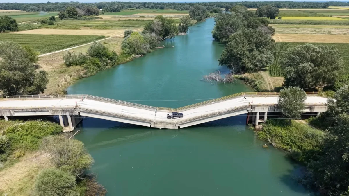
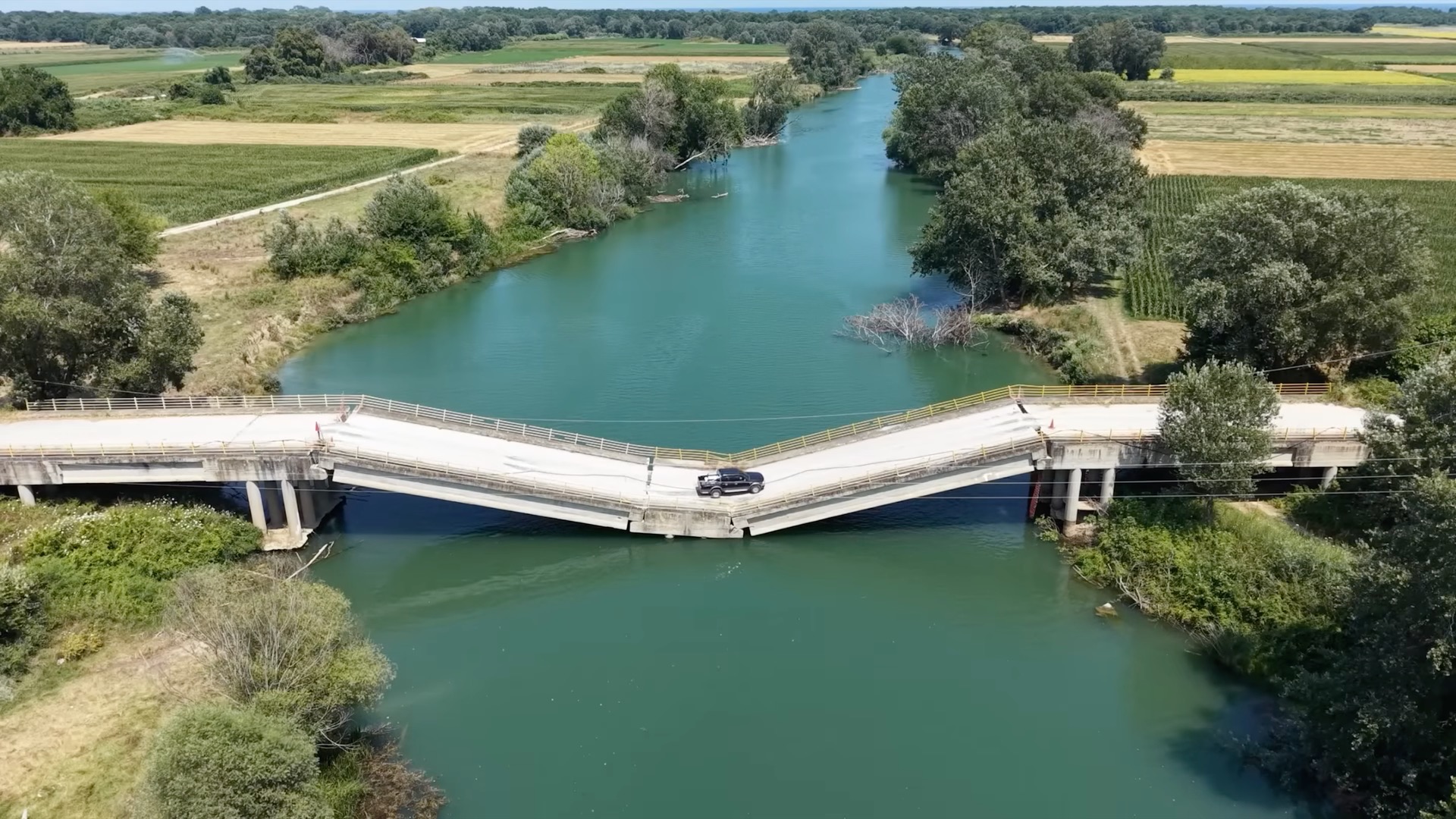
In the rural heart of Thessaly, Greece, the daily commute for local farmers and residents has taken a turn for the perilous. Three years after the catastrophic Storm Daniel rendered the Palaeopyrgos Bridge structurally unsound, the local community has collectively decided that convenience outweighs the risk of a fatal collapse. Despite the span having buckled into the Pineios River like a soft sheet of metal, it remains an active, albeit unofficial, thoroughfare for those looking to shave minutes—and precious fuel—off their journey.
The situation has escalated from a local nuisance into a bizarre case study of infrastructure decay, regulatory paralysis, and the triumph of human impatience over basic safety protocols.
The Anatomy of the Collapse: A Legacy of Storm Daniel
To understand why drivers are risking their lives on a compromised bridge, one must look back to September 2023. Storm Daniel, a "medicane" of historic proportions, swept through the Mediterranean, bringing unprecedented rainfall to Greece, Bulgaria, Turkey, and Libya. In Thessaly, the sheer volume of water turned the Pineios River into a torrent that overwhelmed existing drainage systems and compromised structural foundations across the region.
The Palaeopyrgos Bridge was one of 79 such structures in the region to suffer catastrophic failure. However, unlike bridges that were completely swept away, the Palaeopyrgos span remained partially intact. The center section succumbed to the pressure of the floodwaters and the shifting earth, sagging dramatically until it rested just inches above the water line. The structure is essentially a suspended, unsupported architectural ghost, hanging by the integrity of its peripheral abutments, yet it has become a shortcut that defies all civil engineering logic.
Chronology of a Failed Infrastructure
- September 2023: Storm Daniel devastates Central Greece, causing massive flooding in the Thessaly region. The Palaeopyrgos Bridge suffers significant structural failure, dipping into the riverbed.
- October 2023–December 2024: Initial emergency response efforts prioritize urban centers, leaving rural infrastructure in a state of suspended animation. Local residents begin testing the bridge’s viability as a crossing point.
- January 2025: Local media reports emerge of passenger vehicles, including pickup trucks and agricultural machinery, using the bridge to bypass the official detours toward the National Highway.
- July 2026: New drone footage surfaces via LarissaNet, capturing a Ford Ranger navigating the sharp, uneven incline of the sagging bridge with nonchalant ease. The footage goes viral, highlighting the complete lack of physical barriers preventing entry.
The Economic Drivers of Risk
The decision to use the bridge is not merely a matter of recklessness; it is an economic calculation. For the farmers of the Larissa region, fuel costs and time efficiency are paramount. The official detour route, which requires traveling to the National Highway, adds significant mileage to every trip. In a rural economy where profit margins are thin and seasonal demands are high, the temptation to use a "shorter" route is overwhelming.
"When you are hauling a load of produce, every kilometer counts," says one local resident, noting that the bridge, despite its sagging posture, feels "solid enough" for a single vehicle. This anecdotal sense of security, however, ignores the reality of structural fatigue. Steel and concrete that have been under constant stress and exposed to the corrosive nature of the river for nearly 36 months are prone to sudden, brittle failure.
The Role of Modern Navigation
Adding a layer of digital complexity to the crisis is the role of modern GPS and navigation systems. Reports indicate that popular mapping applications, which often aggregate user-generated data or rely on outdated base maps, continue to route drivers across the bridge. For an outsider or a delivery driver unfamiliar with the local terrain, the bridge appears as a standard, viable road.
This creates a dangerous feedback loop: drivers use the bridge, GPS systems detect traffic flow, the algorithms categorize the bridge as an active road, and more drivers are directed toward the hazard. This "algorithmic entrapment" has turned a local problem into a potential regional disaster waiting to happen.
Official Silence and Regulatory Paralysis
Perhaps the most alarming aspect of the Palaeopyrgos Bridge saga is the lack of a tangible response from the Greek authorities. While the bridge is officially classified as closed, there is a yawning gap between bureaucratic classification and physical reality.
The Enforcement Void
There are no concrete barriers, no steel gates, and no permanent police checkpoints to prevent vehicles from mounting the bridge. The absence of physical deterrents suggests a lack of resources or, more cynically, an unwillingness to enforce a closure that would cause significant political friction with the local voting base who rely on the crossing.
The Funding Crisis
Infrastructure repair in the wake of Storm Daniel has been a point of national contention. Greece, having faced immense financial strain over the last decade, has struggled to secure the necessary funding for the wholesale replacement of its secondary road networks. While highways and urban bridges have seen rehabilitation, rural crossings like the Palaeopyrgos are often left at the bottom of the priority list. This "neglect by design" leaves residents with a choice between a failing, dangerous bridge or an impossibly long detour.
Implications for Public Safety
The implications of this situation are dire. The bridge is not merely a structural hazard; it is a legal and ethical quagmire.
- Structural Integrity: Engineers warn that the bridge is likely in a state of "unstable equilibrium." The constant weight of vehicles, even small pickups, induces dynamic loading that the already-weakened structure was never designed to bear in its current state.
- Emergency Response: Should the bridge collapse while occupied, it would trigger a complex, dangerous, and expensive water rescue operation. The riverbed is unstable, and the remnants of the bridge would create a hazardous obstacle for rescuers.
- Liability: Who is responsible if a tragedy occurs? The local municipality, which failed to block the access? The regional government, which failed to perform repairs? Or the driver, who knowingly traversed a closed road? These questions remain unanswered, leaving a vacuum of accountability.
A Call for Intervention
The viral nature of the recent drone footage has put the spotlight squarely on the authorities in Larissa. While social media provides a platform for the absurdity of the situation—seeing a Ford Ranger treat a broken bridge like an off-road obstacle course—it also provides a clear mandate for action.
Safety experts argue that the immediate installation of Jersey barriers, earth berms, or heavy-duty bollards is the only way to stop the flow of traffic. Furthermore, the local government must coordinate with digital mapping companies to ensure the bridge is flagged as "permanently closed" in navigation databases.
The Palaeopyrgos Bridge serves as a stark reminder that infrastructure is not just concrete and steel—it is a social contract. When the state fails to maintain that contract, the community inevitably begins to forge its own, often dangerous, alternatives. Until officials act, the bridge will remain a ticking time bomb, waiting for the day when the center section finally decides to give way, turning a convenient shortcut into a site of national mourning.
For now, the farmers of Larissa continue to drive across the sag, betting their lives against the structural integrity of a bridge that has already lost the battle against the elements. It is a gamble that, statistically, cannot be won forever.
