



Main Facts: Solving the "Blind Spot" of the Abyss
For decades, the exploration of the ocean floor has been hampered by a persistent, frustrating physical reality: visibility. When remotely operated vehicles (ROVs) or autonomous underwater vehicles (AUVs) approach the seabed to conduct research, repair infrastructure, or survey sensitive sites, the physical interaction between the vehicle and the substrate often kicks up massive, opaque clouds of sediment. For optical cameras, this is the equivalent of trying to drive through a blizzard with high beams on. The result is a total loss of situational awareness, forcing operators to bring expensive, high-stakes missions to a standstill while they wait for the "dust" to settle—a process that can take hours or even days.
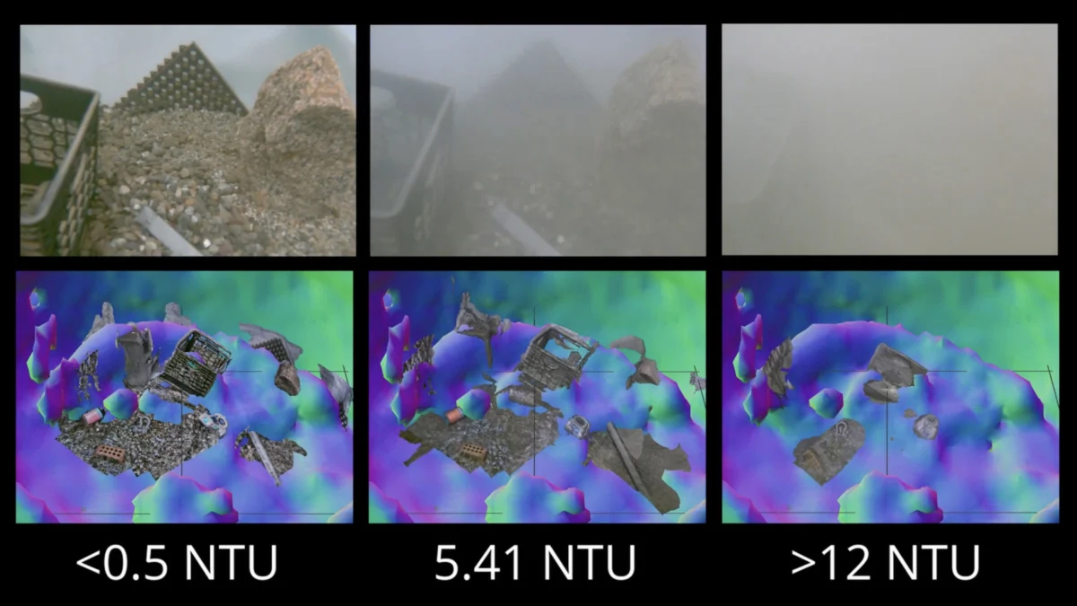
A breakthrough from the Woods Hole Oceanographic Institution (WHOI) promises to change this paradigm. Amy Phung, a doctoral candidate, and her advisor, Dr. Richard Camilli, have pioneered a hybrid navigation system that effectively allows underwater robots to "see" through turbidity. By integrating high-frequency sonar with advanced real-time image-matching algorithms, the team has enabled robotic systems to construct accurate 3D maps of their surroundings in zero-visibility conditions. This technological leap ensures that underwater vehicles can navigate complex, delicate, or hazardous environments with the precision of a human guide, even when the water is thick with suspended silt.
Chronology: From Academic Concept to Deep-Sea Solution
The Genesis of the Research (2020–2022)
The project began as an inquiry into the limitations of current sensor suites on ROVs. Phung and Camilli identified that while optical sensors provided the high-resolution imagery necessary for scientific classification, they were fundamentally unreliable for navigation in the chaotic, sediment-heavy environments where robots are most needed. The researchers spent years studying the fluid dynamics of sediment clouds and the acoustic scattering properties of different seafloor types.
Algorithmic Integration (2023)
The turning point occurred when the team began looking for ways to process sonar data in real time. Traditional sonar processing is computationally expensive, often resulting in significant lag between data collection and visualization. Phung turned to a novel image-matching algorithm—originally developed by researchers in France—designed to estimate the relative depth of individual pixels in a 2D scene. By adapting this algorithm to process sonar echoes rather than optical pixels, the WHOI team successfully reduced the computational overhead, allowing for the generation of "instant" 3D representations of the environment.
Field Validation and Refinement (2024–Present)
Following successful simulation trials, the system was moved to controlled tank testing at WHOI’s facilities. By mimicking the "benthic storm" effect—the cloud of silt kicked up by an ROV thruster—the team proved that the vehicle could maintain its spatial orientation and proximity to target objects without visual contact. The system is currently transitioning into iterative field testing, with plans for integration into deep-sea autonomous missions.
Supporting Data: How the System Works
The core of the WHOI innovation lies in its "sensor fusion" approach. The system does not attempt to replace optical cameras; rather, it uses sonar as a strategic precursor to visual identification.
The Mechanism of Real-Time Mapping
- Acoustic Ranging: As the ROV approaches a target, it emits high-frequency sonar pulses. Unlike light, these acoustic waves are unaffected by suspended particulate matter.
- Depth Estimation: The French-developed algorithm analyzes the returning acoustic echoes. By comparing the intensity and timing of the signals, the algorithm assigns a relative depth value to every point in the 2D plane, effectively "painting" a 3D depth map of the surroundings.
- Dynamic Positioning: As the vehicle moves, the system continuously updates this map. By matching successive "frames" of sonar data, the vehicle can calculate its own drift and position relative to the target with centimeter-level accuracy.
- Visual Transition: Once the vehicle has safely maneuvered into a stable position close to the target, it pauses, allowing the sediment cloud to disperse. The high-resolution optical cameras then take over for the final identification or manipulation task.
Performance Metrics
In preliminary tests, the system demonstrated an ability to map surroundings at speeds exceeding traditional point-cloud generation methods by a factor of ten. This latency reduction is the "holy grail" of subsea robotics, as it allows the vehicle to make split-second course corrections to avoid collisions with fragile corals, historic shipwrecks, or unstable underwater infrastructure.
Official Responses: The Human Element of the Deep
Dr. Richard Camilli, a veteran of subsea exploration, emphasizes that the utility of this technology lies in its ability to humanize robotic behavior. In explaining the function of the system, he invokes a relatable, if daunting, scenario:
"An analogy would be if you were to go into a china shop in the dark, and try to pick your way around to find a specific coffee mug without knocking things over," says Camilli. "This would allow you to do that. It transforms a chaotic, blind environment into a structured map that a robot—or a human operator—can navigate with confidence."
Amy Phung, whose research forms the bedrock of this project, notes that the implications for scientific research are profound. "We often have to skip the most interesting areas of the ocean floor because the sediment is too soft, and our vehicles kick up too much debris to safely work there. We aren’t just improving efficiency; we are expanding the geography of the reachable world."
Implications: A New Frontier for Industrial and Scientific Exploration
Scientific Exploration and Marine Biology
For marine biologists, the ability to operate in high-turbidity zones means being able to study benthic ecosystems that were previously considered "no-go" zones. This includes the study of deep-sea hydrothermal vents and soft-sediment habitats where biodiversity is high but visibility is frequently obscured by sulfurous or silt-heavy plumes.
Underwater Infrastructure and Maintenance
The global economy relies heavily on subsea infrastructure, including telecommunications cables, offshore wind farms, and oil and gas pipelines. Maintenance of these assets is a multi-billion-dollar industry. Currently, if an ROV creates a cloud of silt during a repair, the mission must be delayed. By eliminating this "wait time," the WHOI system could reduce the operational costs of offshore maintenance by 20% to 30%, while simultaneously reducing the risk of accidental damage to sensitive infrastructure.
Defense and National Security
One of the most sensitive applications mentioned by the researchers is the handling of unexploded ordnance (UXO) and undersea mines. These devices are often buried partially in sand or hidden in silt-heavy environments. The risk of disturbing such devices is extreme; using optical cameras to find them often requires getting too close for comfort, but using traditional sonar is often too imprecise. The WHOI system offers a "middle ground" of safe, high-resolution navigation that could revolutionize the clearance of dangerous underwater sites, making the oceans safer for both commercial shipping and military operations.
The Path Forward
The next steps for Phung and Camilli involve hardening the technology for deployment in extreme deep-sea conditions, where pressure and temperature variations can affect sensor calibration. They are also exploring the integration of AI-driven object recognition, which would allow the system to not just map the seafloor, but to autonomously identify specific objects of interest—such as a specific type of clam or a structural defect in a pipe—without any human input.
As the world turns its attention toward the "blue economy," the ability to navigate the ocean floor with clarity is no longer a luxury; it is a necessity. By turning the dark, swirling clouds of the seafloor into a navigable map, the team at WHOI has ensured that our robotic envoys can go where humans cannot, revealing the secrets of the deep with unprecedented precision. The dust may be settling on this research, but the implications for the future of oceanography are only just beginning to rise.
